
What Is Drone Surveying?
Walking a large, uneven site with a ground crew can take days. Thick brush, steep slopes, and active equipment make the work slower and riskier. Drone surveying collects much of that same site data from the air, often with far less time in the field.
Drone surveying uses unmanned aircraft to capture images or LiDAR data over a site. Software turns that data into maps, 3D models, and elevation surfaces for planning and building. For developers, builders, and civil engineers, the takeaway is simple: drone data is fast and detailed, but its value depends on good planning, ground control, and the right sensor.
What Is Drone Surveying and How Does It Work?
Drone surveying is the process of flying a drone over a site to collect measurable data. The drone follows a planned flight path at a set height and speed. A sensor on board records the ground, and software turns those records into maps and models.
Photogrammetry vs. LiDAR
Most survey drones carry a camera or a LiDAR sensor. A camera captures hundreds of overlapping photos, and photogrammetry software matches points across them to build maps and 3D surfaces. This works well on open ground with clear sight lines.
A LiDAR sensor sends out laser pulses and measures how long each one takes to return. Each return becomes a point with a location and elevation. Millions of these points form a point cloud, which is a 3D record of the site. Some pulses slip through gaps in trees and reach the ground, so drone LiDAR mapping works well on wooded land where cameras only see the canopy.
What Affects Accuracy
Results depend on more than the drone. Sensor quality, flight height, point density, vegetation, and ground conditions all play a role. Ground control points also matter. These are marked targets with known coordinates that tie aerial data to a real-world coordinate system. Ask your provider how they check accuracy and what you can expect on your site.
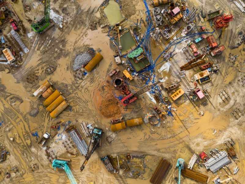
Orthomosaic Mapping for Accurate Aerial Site Visualization
An orthomosaic is a single map-quality image stitched together from many drone photos. Software corrects each photo for tilt and terrain so distances stay true. The result looks like a sharp aerial photo, but you can measure from it.
Teams use orthomosaics to see the whole site at once. Planners mark access roads, drainage paths, and existing structures. Contractors compare field conditions to design drawings, and owners get an image they can share with lenders or partners.
An orthomosaic only shows what the camera can see. It won’t reveal ground hidden under dense trees or tall grass. If you need bare-earth elevations in wooded areas, pair it with a LiDAR survey and confirm the resolution and coordinate system before the flight.
Aerial Site Inspections for Construction and Infrastructure
Aerial inspections let teams check structures without putting people in risky spots. A drone can view roofs, bridge decks, towers, retaining walls, and slopes up close. Crews stay on the ground while the drone captures photos, video, or scan data.
This approach suits places that are slow or unsafe to reach. Steep embankments, utility corridors, and active work zones are common examples. Inspection data can flag cracks, erosion, or standing water early, when repairs are often smaller.
A drone inspection supports a qualified inspector. It doesn’t replace their judgment or any inspection a code or agency requires. Before you book a flight, confirm what the inspector needs to see, at what detail, and in what format.
Construction Progress Monitoring With Drone Data
Progress monitoring means flying the same site on a regular schedule and comparing results. Weekly or monthly flights build a visual record of the work. Each new dataset shows what changed since the last one.
Drone data helps teams track several things:
Earthwork volumes. Repeat surveys show how much soil was cut, filled, or hauled.
Stockpile quantities. Aerial volume checks are faster than measuring piles by hand.
Schedule status. Side-by-side maps show which areas are on track.
Design compliance. Overlaying design files on fresh data can reveal grading issues early.
Consistency makes this work. Use the same control points, flight settings, and coordinate system each time, or comparisons may show false changes. Set the schedule and deliverables before groundbreaking so your first flight becomes a clean baseline.
How Drone Surveying Supports Site Planning and Development
Good site plans start with good existing-conditions data. Drone surveying gives designers terrain models, contours, and aerial images early in a project. That information shapes grading, drainage, building placement, and road layout.
LiDAR mapping is especially useful on raw, wooded land. A drone LiDAR survey can model the ground under trees and expose slopes, low spots, and natural drainage paths. Finding these early helps control earthwork costs and avoid redesigns.
Drone data has limits you should plan around. It doesn’t establish legal property lines, so boundary work still requires a licensed surveyor. Confirm accuracy needs, coordinate systems, file formats, site access, and timing early, since airspace rules and weather can also affect flight dates.
Frequently Asked Questions
Is drone surveying accurate?
Drone surveying can be very accurate when the project is planned well. Accuracy depends on the sensor, flight height, ground control, site conditions, and processing. A reputable provider should explain the accuracy they expect and how they check it. Set your accuracy goals before the flight, not after.
What is the difference between drone LiDAR and photogrammetry?
Photogrammetry builds maps from overlapping camera photos. LiDAR uses laser pulses to measure distances and build a point cloud. LiDAR can reach the ground through gaps in vegetation, while photos only show visible surfaces. Many projects use both to get clear images and reliable terrain data.
How long does a drone survey take?
Field time is often shorter than a ground survey of the same area. Timing depends on site size, terrain, weather, airspace, and the deliverables you need. Processing adds time after the flight. Ask your provider for a schedule that covers flight, processing, and delivery.
Can drone surveying replace a land survey?
Drone surveying can replace some field data collection, but it doesn’t replace licensed surveying. It can’t establish legal property boundaries on its own. Many projects use drone data alongside work by a licensed surveyor or engineer. Check which services your project, lender, or reviewing agency requires.
What files will I receive from a drone survey?
Common deliverables include orthomosaics, point clouds, terrain models, contour maps, and volume reports. File formats vary by provider and project. Tell your provider which software your team uses so the files open and align correctly. Confirm the coordinate system and units at the start.
